Geographic Information Systems (GIS) have become an essential part of modern-day navigation, revolutionizing how we travel, locate places, and manage spatial information. Whether we are using apps like Google Maps or a sophisticated fleet management system, GIS plays a critical role in ensuring accurate, real-time navigation.

Before diving into the specifics of how GIS is used in navigation, it’s crucial to understand what GIS actually is. Geographic Information Systems (GIS) refer to a framework that gathers, manages, and analyzes spatial and geographic data. At its core, GIS allows us to visualize and interpret data that has a geographic or spatial component, helping us to make informed decisions based on physical locations and patterns.
Definition of Geographic Information Systems (GIS)
GIS is more than just a mapping tool. It’s a powerful system that integrates several types of data. It captures, stores, manipulates, and presents data related to positions on the Earth’s surface. GIS data can include everything from simple addresses and coordinates to more complex data sets like population density, climate data, or even infrastructure layouts.
For instance, a city planner may use GIS to overlay maps of transportation routes, property lines, and zoning restrictions. This allows them to visualize how changes to one element (like road construction) might impact other parts of the system (such as traffic flow or property access).
How Does GIS Work?
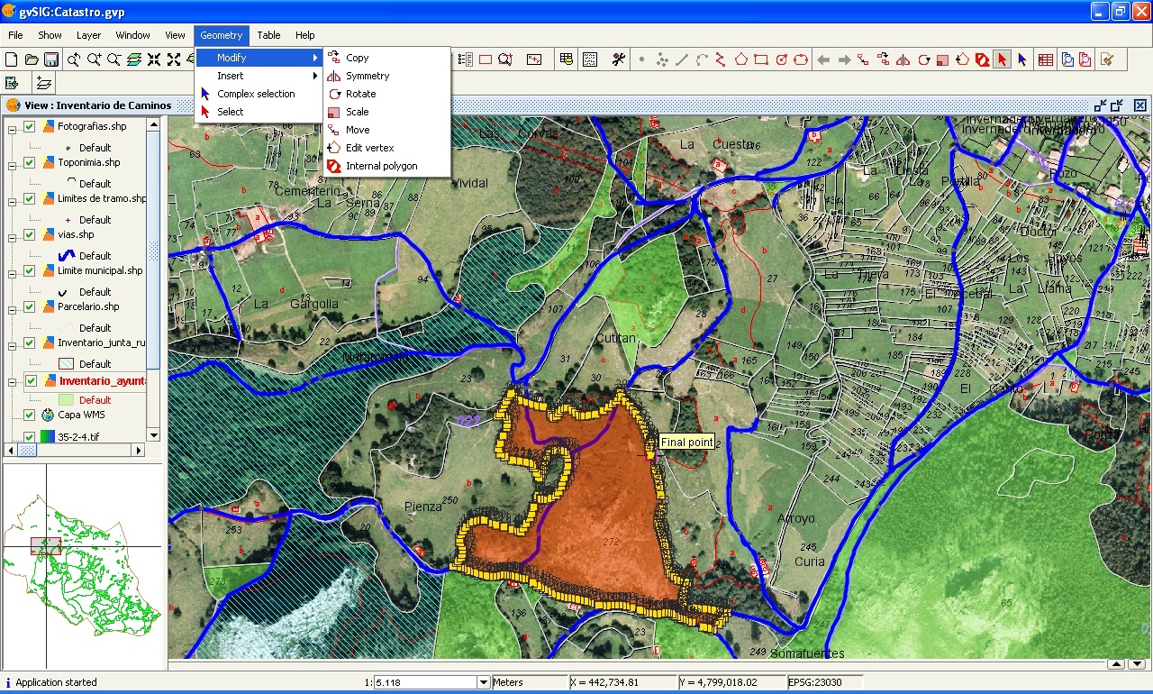
The technology behind GIS works by capturing data from multiple sources such as satellite imagery, GPS devices, and sensors. This data is then layered and analyzed using software designed to handle complex spatial information. GIS software allows users to view, interpret, and visualize data in ways that reveal patterns, relationships, and trends in the form of maps, reports, and charts.
- Data Collection: GIS systems gather data from various sources, including aerial photographs, GPS satellites, and IoT sensors.
- Data Storage: The data is then stored in large databases, often using cloud-based services for scalability.
- Data Analysis: Analysts and decision-makers use this data to run models, create visualizations, and gain insights into spatial relationships.
- Data Presentation: GIS presents data in user-friendly formats such as maps, graphs, and tables, making it easy to understand complex spatial information.
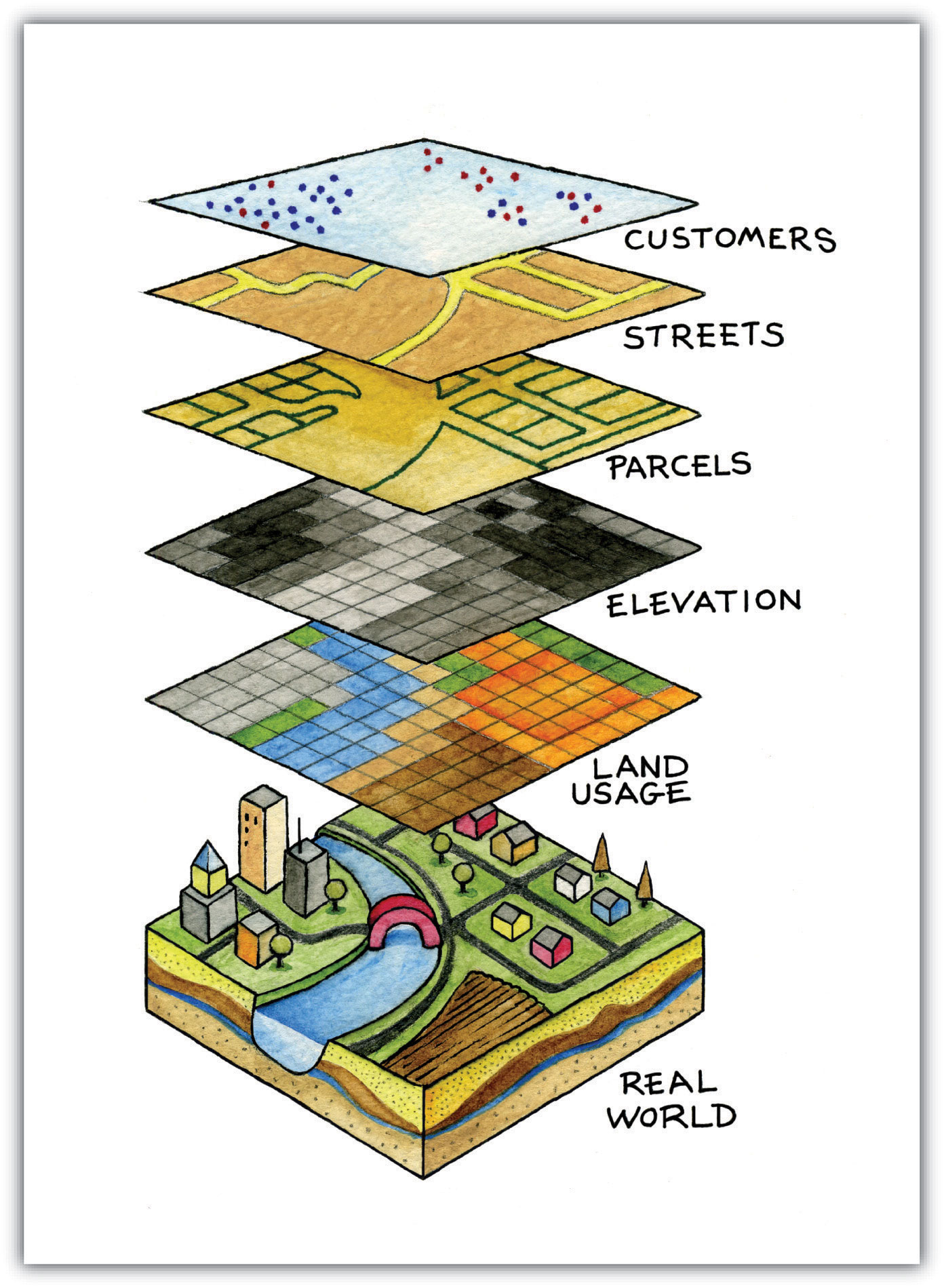
In essence, GIS works like a layered cake of data—each layer representing a different set of information (roads, weather, population, etc.)—which when combined offers a comprehensive view of an area.

How Is GIS Used in Navigation?
The use of GIS in navigation has revolutionized how we move from one place to another. Whether it’s finding the fastest route to work or guiding large fleets of vehicles across the country, GIS plays a crucial role in helping us get where we need to go. Navigation systems powered by GIS combine real-time data, spatial analysis, and mapping to provide accurate and efficient route information.
Real-Time Route Mapping
One of the most well-known uses of GIS in navigation is real-time route mapping. When you open an app like Google Maps or Waze, what you’re seeing is the result of complex GIS systems at work. These systems not only provide static maps but constantly update them with real-time data from a variety of sources.
- Traffic updates: GIS gathers data from millions of mobile devices, traffic cameras, and sensors embedded in roads to monitor traffic conditions. This allows navigation apps to show real-time congestion and suggest alternate routes.
- Road closures and accidents: GIS also plays a role in identifying roadblocks, accidents, or construction zones. The system updates the map, allowing drivers to reroute accordingly.
- Dynamic recalculation: If a driver misses a turn, GIS systems recalibrate the route in real-time, taking into account traffic conditions, road closures, and other obstacles.
Integration with GPS (Global Positioning System)
While GIS forms the backbone of navigation systems, it works hand-in-hand with GPS technology. GPS provides the exact position of the user or vehicle, while GIS offers the contextual data needed to navigate from point A to point B.
- GPS for Positioning: GPS uses a network of satellites to pinpoint the location of a user or vehicle. This data is then fed into the GIS, which overlays this location on a map and calculates the optimal route.
- GIS for Mapping and Context: GIS provides the “brains” of the operation by integrating geographic information such as road networks, landmarks, and points of interest. This combination ensures that GPS doesn’t just give a location but a meaningful path to the destination.
Traffic and Road Condition Monitoring
GIS systems play a significant role in monitoring traffic and road conditions, which are then fed into navigation systems for real-time updates. By analyzing traffic data, navigation systems can:
- Suggest the fastest route: GIS analyzes current traffic patterns to suggest the quickest route, avoiding traffic jams and roadblocks.
- Predict travel times: Based on traffic flow data and historical patterns, GIS can estimate the time it will take to reach a destination, making it easier for users to plan trips.
- Dynamic route adjustments: If an unexpected delay occurs (such as an accident), GIS can immediately recalculate and provide a new route, minimizing time spent in traffic.
Fleet and Logistics Management
In the transportation and logistics sector, GIS is invaluable for managing fleets and optimizing delivery routes. Companies that manage large fleets of vehicles rely on GIS-based navigation systems to track vehicle locations, monitor performance, and plan the most efficient routes.
For example:
- Vehicle tracking: Fleet managers can use GIS to monitor the real-time location of each vehicle in the fleet. This ensures that deliveries are on schedule and allows for quick adjustments in case of delays.
- Route optimization: GIS can calculate the most efficient route for multiple deliveries, reducing fuel costs and ensuring timely delivery.
- Predictive maintenance: By integrating vehicle data with GIS, fleet managers can plan maintenance schedules based on travel distances and environmental conditions, improving overall efficiency.
Emergency Response and Navigation
One of the most critical uses of GIS in navigation is in emergency response. When time is of the essence, accurate and efficient navigation can mean the difference between life and death. Emergency services such as ambulances, fire departments, and police forces rely on GIS for routing during emergencies.
- Fastest and safest routes: GIS helps emergency responders find the quickest route to an emergency scene, accounting for traffic, road conditions, and obstacles.
- Resource allocation: During large-scale emergencies, GIS is used to allocate resources more effectively. By mapping out incidents and available resources, dispatchers can send the nearest available emergency vehicle.
- Community safety mapping: GIS can analyze spatial data to map out high-risk areas, such as locations prone to accidents or natural disasters. This information helps emergency planners to prepare and respond more efficiently.
Examples of GIS in Real-World Navigation
- Google Maps: One of the most widely used navigation tools, Google Maps uses GIS to provide real-time navigation, traffic updates, and route planning. It incorporates live data from mobile devices, GPS, and traffic sensors.
- UPS Routing Systems: UPS, a global leader in logistics, uses a GIS-based navigation system to optimize delivery routes for its drivers. This system helps reduce fuel consumption, decrease travel time, and improve delivery efficiency.
- Emergency Response Systems: Many cities and municipalities use GIS-based systems to coordinate emergency response efforts. These systems provide real-time information about traffic conditions, road closures, and resource availability, helping responders reach incidents faster.
GIS is a key technology in modern navigation, providing the foundation for everything from real-time route mapping to emergency response. It integrates complex data from multiple sources to offer a seamless navigation experience, whether for individual users or large fleets.

What Are the Key Features of GIS in Navigation?
GIS is not just about maps; it encompasses a wide range of powerful features that make it indispensable for modern navigation systems. By utilizing these key features, GIS ensures that navigation systems provide accurate, efficient, and reliable guidance to users. Below, we’ll explore the core features that make GIS essential in navigation.
Geospatial Data and Mapping
At the heart of GIS is the ability to manage and analyze geospatial data—data that has a geographic component. This feature is what allows GIS to map physical spaces and represent various data points on a map.
- Layered Mapping: One of the most valuable aspects of GIS is the use of layers. A GIS map is like a stack of transparent layers, where each layer represents a different set of data (such as roads, buildings, and vegetation). By toggling layers on and off, users can focus on specific information relevant to their navigation needs.
- Visualizing Spatial Relationships: GIS makes it easy to visualize relationships between different geographic features. For example, in a delivery service, a company might layer traffic conditions over customer locations to optimize delivery routes.
- Continual Updates: Unlike static maps, GIS maps are continuously updated. They pull in real-time data, ensuring that the map reflects current conditions, such as traffic, weather, or road closures.
Case Study: Smart City Traffic Management
In many smart cities, GIS plays a central role in traffic management. For example, in Singapore, a comprehensive GIS system monitors traffic flow, adjusting traffic lights and suggesting alternate routes to avoid congestion. This not only improves daily commutes but also reduces environmental impacts by cutting down on idle time in traffic.
Route Optimization Algorithms
One of the standout features of GIS in navigation is its ability to calculate the most efficient routes. Route optimization algorithms are embedded in GIS systems to help users reach their destinations as quickly and efficiently as possible.
- Shortest Path Calculation: GIS systems use advanced algorithms to calculate the shortest or fastest path between two points. This is particularly useful in logistics, where minimizing travel time or fuel consumption is essential for cost savings.
- Factors Considered: GIS systems don’t just rely on distance alone. They also take into account factors like:
- Current traffic conditions
- Road types (highways vs. local roads)
- Speed limits
- Traffic lights and stop signs
- Customizable Routes: GIS navigation allows users to input preferences, such as avoiding toll roads or favoring scenic routes, and the system will optimize accordingly.
Real-Time Data Integration
Real-time data integration is what sets modern GIS navigation systems apart from traditional paper maps. GIS systems constantly pull in real-time data from various sources, including traffic sensors, weather stations, and mobile devices.
- Live Traffic Updates: By integrating live traffic data, GIS navigation can suggest alternate routes in case of traffic jams or road closures. For instance, systems like Waze collect user-generated data about traffic conditions and update routes in real-time.
- Weather Data: GIS systems can also integrate real-time weather data, which is particularly useful in navigation. For example, in shipping or aviation, knowing about incoming storms or adverse weather conditions can help navigators choose safer routes.
- Incident Reports: Data about accidents, construction work, or police activity is integrated into GIS to keep users informed and help them make timely route adjustments.
User Interface and Visualization
While all of the technical data behind GIS is crucial, it’s just as important that the end-user can easily interact with the system. User interface (UI) and visualization are key components of any GIS-based navigation system.
- Interactive Maps: Users can interact with the map in real-time, zooming in and out, panning across the map, and switching between different layers (e.g., satellite view, traffic view, etc.).
- Turn-by-Turn Directions: Modern navigation systems offer turn-by-turn directions, both visually and audibly. GIS provides the data necessary to break a journey into clear, manageable steps.
- Clear Visual Cues: Well-designed GIS navigation systems use symbols, color coding, and text to make navigation easier. For example, highways are typically displayed in different colors from local roads, and points of interest (such as gas stations or restaurants) are clearly marked.
Example: Google Maps UI
One of the reasons Google Maps is so widely used is its intuitive interface. The GIS-powered system not only offers a clear, interactive map but also integrates live traffic updates, suggested routes, and clear visual indicators for upcoming turns. By presenting complex data in a simple, user-friendly format, Google Maps allows users of all technical skill levels to navigate with ease.
GIS’s combination of layered mapping, route optimization algorithms, real-time data integration, and user-friendly interfaces make it a powerful tool in modern navigation systems.

What Industries Benefit from GIS in Navigation?
The versatility and power of GIS in navigation extend beyond personal use. Various industries depend on GIS to optimize routes, enhance efficiency, and make data-driven decisions. From transportation to urban planning, GIS has transformed how industries approach navigation. Below are some key industries where GIS has made a significant impact.
Transportation and Logistics
In the world of transportation and logistics, GIS is indispensable. Companies that manage fleets of vehicles or oversee complex supply chains rely on GIS for optimizing routes, tracking deliveries, and ensuring efficient fleet management.
- Fleet Management: GIS helps logistics companies track vehicles in real-time, ensuring that deliveries are on schedule and routes are optimized. This minimizes fuel costs, reduces delays, and improves customer satisfaction.
- Route Optimization: Delivery services like FedEx and UPS use GIS to analyze traffic patterns, road conditions, and delivery points to calculate the most efficient routes. This helps them meet tight delivery windows while keeping costs down.
- Predictive Analytics: GIS systems in logistics also provide predictive analytics, helping companies anticipate potential delays due to weather, traffic, or road conditions. These systems can automatically reroute vehicles to avoid obstacles, ensuring deliveries are made on time.
Case Study: UPS Route Optimization
UPS, one of the world’s largest delivery companies, uses a GIS-powered system known as ORION (On-Road Integrated Optimization and Navigation). ORION analyzes millions of data points daily to determine the most efficient routes for drivers. By reducing the number of left turns and optimizing routes, UPS has saved millions of gallons of fuel and cut down delivery times. This is a perfect example of GIS’s potential to transform logistics.
Urban Planning and Development
Urban planners and developers use GIS to make critical decisions about infrastructure, land use, and transportation networks. GIS allows them to visualize complex spatial relationships between various elements of a city, such as roads, buildings, green spaces, and utilities.
- Traffic Management: Urban planners use GIS to manage traffic flow by analyzing traffic patterns and designing road networks that alleviate congestion. By simulating different traffic scenarios, they can determine where to place new roads or public transport systems to improve mobility.
- Infrastructure Development: GIS is also essential for planning infrastructure projects like roads, bridges, and tunnels. Planners use GIS to assess the environmental impact, analyze geographic features, and determine the best locations for new developments.
- Zoning and Land Use: In urban development, GIS helps authorities decide on zoning regulations by overlaying maps that show population density, land use, and available services. This ensures that cities grow in a sustainable and efficient manner.
Example: Singapore’s Smart City Initiative
Singapore is a leader in using GIS for urban planning as part of its Smart City initiative. The government uses GIS to manage everything from traffic systems to public transport and infrastructure development. For instance, Singapore’s Land Transport Authority relies on GIS to monitor traffic in real-time, adjusting traffic lights and public transport routes to reduce congestion and improve traffic flow.
Aviation and Marine Navigation
GIS is also a critical tool in both aviation and marine navigation, where precise location data is essential for safe and efficient travel. These industries rely on GIS to manage flight paths, sea routes, and air and sea traffic in real-time.
- Flight Path Optimization: Airlines use GIS to plan optimal flight paths, taking into account weather conditions, air traffic, and fuel consumption. GIS also helps avoid restricted airspace or natural obstacles like mountains.
- Marine Route Planning: Ships use GIS to navigate safely through waters, particularly in areas with complex coastlines or congested shipping lanes. GIS systems help maritime professionals avoid hazards such as shallow waters, reefs, or other vessels.
- Port Management: GIS is also used in managing ports, optimizing ship docking schedules, and handling cargo more efficiently.
Example: GIS in Air Traffic Control
Air traffic controllers use GIS to monitor and manage airspace, ensuring that aircraft stay on safe paths and avoid collisions. The Federal Aviation Administration (FAA) in the United States relies on GIS to oversee the safe and efficient movement of thousands of flights each day. By integrating real-time weather data and air traffic information, GIS ensures that flights are routed to avoid storms and other disruptions.
Tourism and Travel
The tourism and travel industry has greatly benefited from GIS-powered navigation systems. Travelers today expect real-time, reliable navigation to guide them through unfamiliar destinations, and GIS makes that possible.
- Tourist Guides and Maps: Many tourist destinations now offer GIS-based mobile apps that provide detailed maps, directions, and points of interest. These apps can guide travelers through cities, national parks, and historical sites, offering personalized routes based on user preferences.
- Route Planning for Travelers: GIS also powers route planning for tourists who want to visit multiple destinations. For example, road trip planning apps use GIS to suggest the best routes, nearby attractions, and accommodations.
- Location-Based Services: GIS integrates with location-based services (LBS) that offer personalized recommendations for restaurants, hotels, and tourist spots based on the traveler’s location.
Example: GIS in Travel Apps
Popular travel apps like TripAdvisor and Google Trips rely on GIS to provide location-based recommendations. Whether users are looking for the best restaurants nearby or the most scenic hiking trail, these apps use GIS to offer personalized suggestions that enhance the travel experience.
From transportation and logistics to aviation, urban planning, and tourism, GIS in navigation plays a transformative role across various industries. By providing real-time data, optimizing routes, and helping manage complex spatial relationships, GIS has become indispensable for organizations aiming to improve efficiency and make smarter decisions.